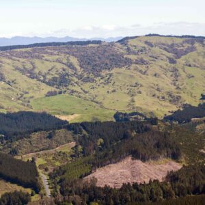
Te Pōhue is located at the south eastern end of the Maungaharuru Range (Maungaharuru). It is within the traditional area of Ngāti Marangatūhetaua (Ngāti Tū) and Ngāi Tauira and near their pā (fortified villages), kāinga (villages), wāhi tapu (sacred places), mahinga kai (places for gathering food) and other significant sites.
Te Pōhue was a large pā, located at the head of Te Pōhue Lake and in the shadow of the maunga (mountain). The summit of the pā, formerly encircled by large tōtara fortifications, had commanding views of the surrounding countryside. From there, Ngāti Tū could survey the surrounding lands . Also nearby were the Ngāti Tū kāinga, Kaitahi and Whāngai Takapu. The significance of this area is also demonstrated by the placement of pou (posts) which were named after key tīpuna including Tūkapua, after the eponymous ancestor Tūkapua I for Ngāti Tū and Kaitahi, a key tīpuna for Ngāi Tauira.
Te Pōhue has always been part of the arterial route from the coast to the interior, in traditional times with the proliferation of walking tracks, as well as in recent times with the old Taupo Coach Road and today with State Highway 5. In the past, the key walking tracks through this area saw the seasonal passage of the Hapū in the summer to Tangitū and in the winter to Maungaharuru. For this reason, this area has constantly been a significant, strategic location, and the Hapū defended their interests in this land over many generations.
The Hapū have cultural, spiritual, traditional and historic associations with Te Pōhue. The Hapū have a responsibility as kaitiaki (guardians) in accordance with their kawa (rules) and tikanga (customs) to restore, protect and manage all those natural and historic resources and sites. This relationship is as important to present day whānau (families) as it was to their tīpuna (ancestors). The continued recognition of the Hapū, their identity, traditions and status as kaitiaki is entwined with Maungaharuru, including Te Pōhue.


